The west should sink those illegal fishing of China as it avoids Kinetic warfare but indulge with media threats
Western history can be seen as having several inflection points: one was 1492, the advent of the “Columbian Era”. The Columbian era is the era of sea-faring, sea-power-based Western colonial and imperial empires. The demise of the Columbian era, was foreshadowed by an Oxford geographer in 1904 who put forth what is now known as the “Heartland Theory”. In a nutshell, it is a land-based theory of power that predicts the end of sea-based powers: “Who rules East Europe (Eurasia) commands the Heartland; who rules the Heartland commands the World-Island; who rules the World-Island commands the world.” It also concluded, “Were the Chinese…to…conquer its territory [of the Russian Empire], they might constitute the yellow peril to the world’s freedom.” This maxim and the anxiety it provoked was red-lined in Brezinski’s “Grand Chess game”: “No Eurasian challenger should emerge that can dominate Eurasia and thus also challenge U.S. global pre-eminence.”
In 1992, Marshall’s protégé, Paul Wolfowitz formulated the above strands into a formal doctrine, in the above mentioned DPG (Defense Planning guidance) document:
“Our first objective is to prevent the re-emergence of a new rival… that poses a threat on the order of that posed formerly by the Soviet Union…to prevent any hostile power from dominating a region to generate global power…The U.S. must… protect a new order that [convinces] potential competitors that they need not aspire to a greater role or pursue a more aggressive posture to protect their legitimate interests. In non-defense areas, we must… discourage them from challenging our leadership or seeking to overturn the established political and economic order. We must maintain the mechanism for deterring potential competitors from even aspiring to a larger regional or global role.”
This can be better understood by looking at a map:
This is a map of the world, drawn from a topologist’s eye. It shows relationships, not distances or area. From this map you can note the following things:
+ China has more borders than any other country in the world. This also gives it the possibility of connecting with more countries than any other.
+ Blue lines/corridors are oceans: The top two thirds is the “world island” or “pivot state”–it contains most of the world’s population, resources, and wealth, and it can be connected as a single entity through overland routes or short ocean hops.
+ The bottom is the Americas. It is topologically isolated from the world island. As sea lane control becomes less important, it will also lose prominence and relative power if the world island unifies. It’s clear that that unifying power will probably arise in China, whose overland paths using high-speed rail, roads, pipelines, and ports can be easily built and connected, in a “new silk road”.
+ The US needs to fracture the world island to maintain its global power. If you color in the places where China is encircled, or where the US is waging war/fracturing societies/creating chaos, this is exactly where the fault lines of the global conflict are, and reveal what US strategy is.
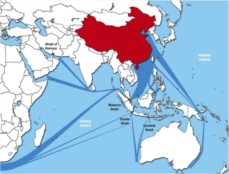
Here is a second map:
Image: CSBA: Shipping Lanes through the South China Sea.
The US has actually surrounded China with 400 military bases, bristling with strategic and tactical weaponry. It also has war-gamed out China’s key vulnerability: the chokepoint of the South China Sea. War in the South China Sea would disrupt $5.3 Trillion of China’s external trade and 77% of China’s oil imports[5]. In this scenario, the US does not have to win a shooting war with China in the South China Sea. The war just has to happen, and the disruption to trade could crash China’s economy. The map shows the shipping lanes that would be disrupted.
China’s first response to the US pivot and encirclement, especially in the South China Sea–its key chokepoint–was to build defensive military facilities along some of the islands, to deter US incursion and to raise the cost of interference. Its other response, much more ambitious, was the Belt & Road Initiative (BRI), which constitutes a long overland escape from the encirclement, similar to its “long march” during its encirclement by the fascist KMT. The BRI travels through SE Asia, then overland through Central Asia, to the Mediterranean, and then Europe and Africa. In particular:
+ CMEC (China-Myanmar Economic Corridor) travels through Rakhine State and exits to the Indian Ocean at Kyaukphyu port (bypassing the Strait of Malacca).
+ CPEC (China-Pakistan Economic Corridor) to Gwadar port transits directly to the Arabian Sea and the Persian Gulf.
+ Xinjiang is the key overland route for BRI to exit China to Central Asia, with Iran also a key node.
+ Djibouti at the horn of Africa is the entry node to Africa (the Sahel, and the South)
BRI as it does this, becomes the physical realization of Mackinder’s “heartland” in Eurasia—the pivot state connecting the “world island” into a single economic bloc, and raising China to the status of the key regional power, exactly what Brezinski and Wolfowitz, sought to prevent.
Image: Mercator Institute for China Studies: Belt and Road Initiative.
Mindful of this development, and aware of the rapidly ticking biological clock on US power, the US is currently rapidly escalating hostilities in the SCS, most recently with war games, U2 incursions, belligerent passages of aircraft carriers, guided missile destroyers, submarines; China’s response has been to launch “carrier killer” missiles into the region.


No comments:
Post a Comment